By Janet Webb – April 18, 2015
John Bailey, manager of Rio Grande del Norte National said those words to me on the day last week when we sat together in his Bureau of Land Management (BLM) Taos field office. I was giving him one last chance to proof the 32-page booklet about the monument before it went to print, before 10,000 copies rolled off the press in Albuquerque.


“It is a treasure owned by every American citizen. Now visitors can learn what locals have known for centuries,” John said. It was then I really realized how monumental the entire effort had been for him and several groups of environmentalists who made this thing happen. Their reward had come almost exactly two years before when President Obama signed the proclamation making over 300,000 acres of northern New Mexico a forever-protected National Monument.
My involvement started a year ago when Webb Design client, MARKETAOS, suggested that visitors to Taos had little concept about the significance of the designation nor how they could use the monument, how to get there, what there was to do when they did get there. So the decision was made to publish a visitor education booklet on the monument, the third in a series MARKETAOS and Webb Design have produced. (The other two are Historic Churches of Northern New Mexico and Historic Taos Walking Tour.)
We received grant funding for the project from New Mexico Tourism Department, Taos County Lodgers Tax Board and Chevron Questa Mine. Sponsorship funds came in from a number of environmental groups and privately-owned recreational outfitters who use the monument land and whitewaters to earn a living. A full list of these supporters can be seen below.
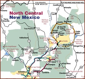
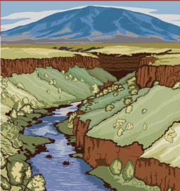
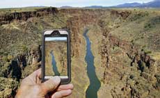
Photographer and author Jim O’Donnell compiled the data and wrote a fascinating self-guided tour. He brilliantly simplified the enormity of the project by dividing the area into ten regions, each with a different set of navigational challenges and rewards. The southernmost region is Taos Junction Bridge at Orilla Verde; the northernmost is Taos Plateau Prairie. The landscapes are radically different with different wildlife and vegetation, but equally as majestic.
Many of Jim’s photographs are included in the guide along with pictures by Geraint Smith, author of “Rio Grande del Norte: An Intimate Portrait,” a 160-page book recently published by Dog Soldier Press. Other local photographers who allowed us to use their images are Gak Stonn, Chris Dahl-Bredine, and Delafield DuBois, a long-time BLM employee. Fly fishing guide Nick Streit, and llama trekker Stuart Wilde and Leah Wilde also contributed images.
The 32-page Rio Grande del Norte National Monument guide booklet is downloadable online at MARKETAOS’s TAOS.org website as well as at Taos Visitor Center (NM State Road 68 at US HWY 64 on the south side of Taos) and at BLM’s two welcome centers – in Pilar and at Wild Rivers area north of Questa. A suggested donation of $1.95 per guide allows for future reprints.
This project was a gratifying collaboration for me. It involved many individuals and organizations who care about preserving the land while keeping it open to mindful use by Taos residents and visitors.

Published by MARKETAOS, formerly Taos County
Lodgers Association and The Town of Taos.
Designed and produced in Taos by Webb Design Inc.
Edited and compiled by Jim O’Donnell with
aid from the Bureau of Land Management,
Taos Field Office.
Special thanks for support from:
New Mexico Department of Tourism
Taos County Lodgers Tax Fund
Partnership for Responsible Business
Bureau of Land Management
Taos Land Trust
Rocky Mountain Youth Corp
Taos County Chamber of Commerce
Albuquerque Wildlife Federation
Conservation Land Fund
Cottam’s River Rafting
Geraint Smith Photo Tours
Geraint Smith’s New Book
Los Rios River Runners
Mountain Skills Rock Guides
New Mexico Wilderness Alliance
New Wave Rafting
Public Lands Interpretive Association
Taos Fly Shop
The Village of Questa
Wild Earth Llama Adventures
The Wilderness Society
Printed in Albuquerque by Starline Printing.
Río Grande del Norte first printing, 2015.
Copyright 2015 MARKETAOS.